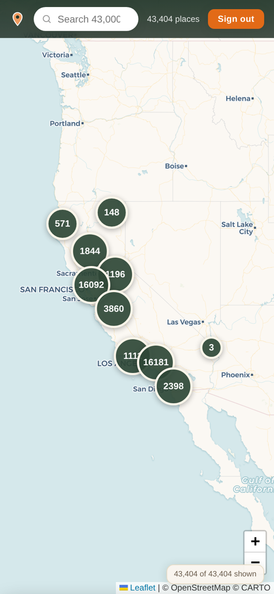
California · All 58 counties
From the missions of El Camino Real to the Mother Lode, the lighthouses of the coast and the studios of Hollywood — 43,000+ historic places on one map, with the stories behind them. Find what's near you, read the story, and go see it.
Free and ad‑free. Sign in with your Apple ID — the same account the iPhone app will use.
What's on the map
Built from the California Office of Historic Preservation, the National Register of Historic Places, the National Park Service, USGS and OpenStreetMap — and checked place by place against the addresses they claim.
All 58 counties
Not just the famous stops. Every region of the state is on the map — places on the map, by region:
Carson Mansion · Fort Humboldt · the Victorian dairy town of Ferndale
2,310The Gold Discovery Site at Coloma · Donner Summit · Manzanar
12,563Alcatraz · the ship Balclutha · Buena Vista, the birthplace of California wine
3,447Monterey's Custom House · Point Pinos Lighthouse · Mission Santa Barbara
5,976Sutter's Fort · Old Sacramento · Allensworth, the town founded by Black Californians
12,847Watts Towers · the Queen Mary · Mission San Juan Capistrano
2,239Riverside's Mission Inn · Barstow's Casa del Desierto · the Lost Horse Mine
2,434Mission San Diego de Alcalá · Old Town · the Star of India
In the iPhone app
Walk it with a guide in your pocket, or head for the hills. Tours and trails live in the iPhone app — coming soon.
A walking tour for every city in California
Narrated stops trigger as you arrive — no guide, no schedule. Every stop is fact‑checked against primary sources and verified to still be standing. The first 39 are written; new cities, big‑city neighborhoods and every four‑year campus are on the way.
12,196 trails across the state
Every one with its route drawn on the map, plus length, surface and difficulty — from a one‑mile loop to the John Muir Trail.
Campus history
From Berkeley's first buildings to mission‑era seminaries, CalRoam maps 502 college and university sites — and is building a guided campus tour for every four‑year college in California. The first, Built to Look Permanent at UC Berkeley, is done.
How it works
Tap Near me, search a name, or filter by category and theme. Every pin has directions one tap away.
Open a pin for its history — the state's own landmark text where it exists, and our sourced write‑ups where it doesn't.
Arrive and check in. Every visit counts toward a ten‑rung ladder in each category and a title in every county.
A real page from the map
“Founded in 1857, this is the birthplace of California wine. Its founder, Colonel Agoston Haraszthy, called the father of the state's wine industry, toured Europe in 1861 to gather grape vine cuttings…”
A look inside

Explore by theme
Fifteen themes tie the places together — filter the map by any of them.
The chain of missions, presidios and asistencias that runs from San Diego de Alcalá to Sonoma — and the road that linked them.
Sutter's Mill, the Highway 49 camps, stamp mills and assay offices — the boom that made the state, still standing in the foothills.
Historic wineries, stone cellars and vineyards in Napa, Sonoma, Mendocino and Amador — starting where California wine did.
Studio lots, backlots, the Walk of Fame and the locations you have seen a hundred times without knowing where they were.
Also: Railroads · Lighthouses · Maritime California · Mexican California & the Ranchos · Chinese American Heritage · Japanese American Incarceration · Native California · Aerospace & Military · Farms & Packing Houses · Literary California · College Campuses
Earn your rank iPhone app
Plus a ladder for every category — visit the missions and climb from Pilgrim and Bell Ringer to Master of El Camino Real.
The map is free and ad‑free, today, in your browser. The iPhone app — with guided tours, trails and check‑ins on the road — is coming soon. Leave your email and we'll tell you the day it lands.
One email when the app launches. No spam, no sharing — see our privacy policy.